Development of Real-Time Mapping System
A detailed overview of a real-time mapping system built with Angular, ASP.NET Core, RabbitMQ, and SignalR, showcasing low-latency live updates of geographic points.
Development of Real-Time Mapping System
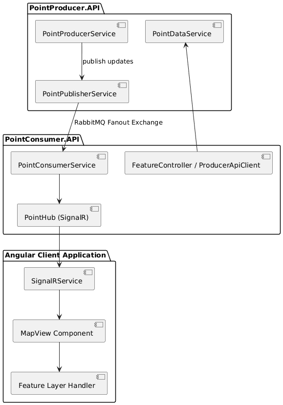
In this project, I built a real-time mapping system that visualizes geographic points on a map with low latency updates. The system is designed as a modern distributed architecture with three main components:
- PointProducer.API (Data Producer Service)
- PointConsumer.API (Data Consumer and Publisher Service)
- Angular/Esri Frontend Client
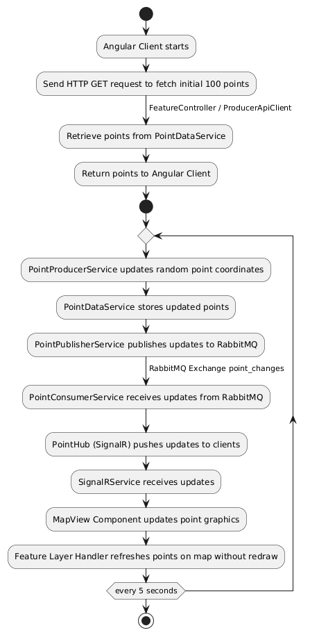
The main goal is to continuously update point coordinates and display them on a map without refreshing the view.
Architecture Overview
The system is composed of the following layers:
1. PointProducer.API
- Stores 100 points in memory in GeoJSON format.
- A Hosted Service updates random point coordinates every 5 seconds.
- Updates are published to RabbitMQ using a fanout exchange (
point_changes). - Configuration (RabbitMQ URI, timing, etc.) is managed via
appsettings.jsonand the IOptions pattern.
2. PointConsumer.API
- Subscribes to RabbitMQ updates from the producer.
- Pushes updates to connected Angular clients using SignalR.
- Implements resilience with Polly to automatically retry on temporary failures.
- Provides HTTP GET endpoints for initial data loading.
3. Angular Client
- Fetches the initial 100 points via HTTP GET from the consumer API.
- Connects to SignalR for real-time updates.
- Updates point coordinates dynamically on the Esri MapView, without re-rendering the entire map.
Package Diagram
Live Update Flow
Here is a simplified activity flow for live updates:
GIF Demonstration
The GIF below demonstrates the real-time updating of geographic points on the map, showing how our system continuously reflects changes without refreshing the view.
![]()
Key Technologies
- Backend: ASP.NET Core Web API, Hosted Service, RabbitMQ, SignalR, Polly, Serilog, JWT
- Frontend: Angular, Esri MapView, SignalR Client
- Data Format: GeoJSON
Challenges & Solutions
- Real-time updates: Achieved with SignalR and in-memory data storage.
- Scalability: RabbitMQ fanout exchange ensures updates reach all connected clients.
- Error handling: Polly provides automatic retry mechanisms for temporary network failures.
- Frontend performance: Only updated points are refreshed on the map, avoiding full redraws.
Conclusion
This project allowed me to explore distributed systems, real-time messaging, and dynamic frontend updates. It demonstrates how modern web technologies can be combined to create low-latency, interactive mapping applications.
GitHub Project: PubSub-Location-Tracker 👈
Prepared by Burhan Sözer
Software Engineering & GIS Solutions