Flood Susceptibility Mapping in Ankara Using M-AHP
A detailed GIS-based flood susceptibility assessment for Ankara using the Modified Analytical Hierarchy Process (M-AHP).
Flood Susceptibility Mapping in Ankara Using M-AHP: A GIS-Based Approach
Urban floods are becoming increasingly common worldwide, and Ankara is no exception. With rapid urbanization, climate change, and aging infrastructure, understanding where floods are most likely to occur has become essential for city planners, policymakers, and disaster‑management teams.
This article summarizes a GIS-based study that applies the Modified Analytical Hierarchy Process (M-AHP) to assess flood susceptibility across Ankara—highlighting high-risk zones and supporting smarter urban planning.
Why Flood Susceptibility Mapping Matters
Floods cause major damage to communities, particularly in dense metropolitan areas. Effective flood susceptibility mapping supports:
- Urban planning and zoning
- Infrastructure and drainage system design
- Emergency response planning
- Climate-adaptation strategies
Given rising rainfall intensity linked to climate change, cities need proactive tools to understand and reduce risk before disasters happen.
Methodology Overview — Why M-AHP?
The Modified Analytical Hierarchy Process is an enhanced decision-support method that:
- Reduces expert bias
- Supports multi-criteria evaluation
- Integrates seamlessly with GIS
- Handles complex natural hazard parameters effectively
This makes M-AHP well-suited for urban flood assessments.
Data Sources Used
1. High-Resolution Photogrammetric Data
Aerial imagery from 2008 and 2015 (30 cm GSD) was used to create:
- Digital Surface Models (DSM)
- Digital Terrain Models (DTM)
- Orthoimage mosaics
These datasets underpin topographic and hydrological analysis.
2. Vector Data (TOPOVT)
Includes rivers, lakes, seasonal streams, and dry drainage channels—critical for modeling natural flow paths.
3. Geological and Environmental Data
- Lithology from national geological datasets
- Land cover derived from Landsat 8 imagery (August 2018)
These help determine permeability, infiltration, and surface-runoff characteristics.
Key Conditioning Factors
The analysis considers multiple factors influencing flood behavior:
- Slope gradient: flatter terrain → higher risk
- Topographic altitude: lower elevations → higher risk
- Flow accumulation: concentrated upstream flow → higher risk
- Distance to drainage channels: closer proximity → higher risk
- Topographic Wetness Index (TWI): water accumulation indicator
- Lithology: permeable units reduce susceptibility
- Land cover: urban and industrial areas increase runoff
Each factor was scored and integrated within the M-AHP framework.
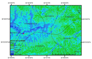
Results: High-Risk Flood Zones in Ankara
The model classified the city into five susceptibility levels: very low, low, moderate, high, and very high.
High-susceptibility areas include:
Yenimahalle & Etimesgut
- Broad alluvial valley floors
- High accumulation potential
Çankaya
- Narrow valley bottoms
- Increased concentration of surface runoff
These regions showed logical correlation with DTM-based terrain features, reinforcing model reliability.
Implications for Urban Planning
The flood susceptibility map provides actionable insights for:
- Infrastructure upgrades
- Building-permit regulations
- Drainage planning
- Emergency response prioritization
As Ankara expands, incorporating these maps into long-term planning is essential for reducing disaster risk.
Future Work
Enhancing the model may include:
- Higher-resolution datasets
- Sentinel-1 & Sentinel-2 integration
- Validation with real flood events
- Localized sub-regional susceptibility mapping
These refinements can improve prediction accuracy and support climate-resilient development.
Conclusion
The M-AHP approach offers a powerful, cost-effective method for flood susceptibility assessment in urban environments. For Ankara, this model provides valuable guidance that can help city officials and planners reduce vulnerability and strengthen long-term resilience.
Prepared by Burhan Sözer
Software Engineering & GIS Solutions